

The Customs and Border Protection MQ-9 Program


In the late 1990s, the United States military began using the RQ-1 Predator to support ground forces in Yugoslavia, in the first instance of unmanned aircraft systems providing persistent surveillance to military forces. In 20021, the RQ-1 began serving in a combat role (which thus changed the system designation to MQ-1: “R” meaning Reconnaissance and “M” meaning Multi-role, and “Q” meaning unmanned aircraft system) as part of the invasion of Afghanistan, launching airstrikes on ground targets. Soon after, in 2007, the MQ-9A Reaper reached initial operating capability in the US Air Force2. The MQ-9A performed many of the same tasks as the MQ-1, but was able to fly further and spend longer over a target. This began a larger program of unmanned aircraft use across the entire United States military, which has grown and persisted to this day. Domestic law enforcement purchases and use of surplus military equipment, such as mine-resistant armoured vehicles3, has become more commonplace in recent years; domestic law enforcement use of these unmanned systems could be seen as a logical next step. The United States Department of Homeland Security (DHS) Customs and Border Protection's Air and Marine Operations (CBP AMO) division operates a fleet of eight MQ-9B remotely-piloted aircraft (RPA). These RPAs are equipped with a number of different sensors, including electro-optical, synthetic aperture radar, and more. This fleet of aircraft has been used to support CBP operations along the US borders, as well as operations abroad in Panama. They have also provided support to a number of domestic law enforcement actions, such as observing protests at the request of federal agencies, or providing persistent surveillance at the request of local law enforcement. This article will go into detail on the history, technology, deployment, and operations of CBP’s MQ-9 program.
UAS Program Background
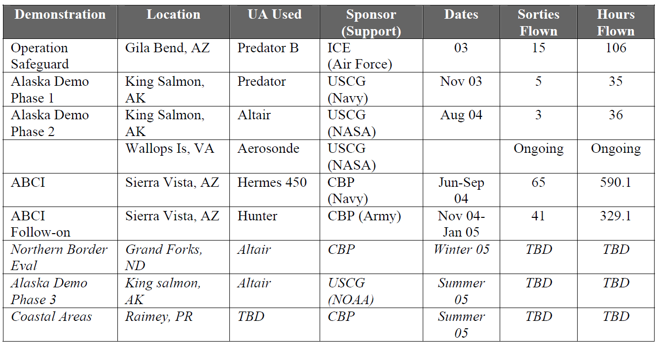
The Department of Homeland Security UAS (Unmanned Aircraft System) program began in November 2003 when Immigration and Customs Enforcement tested the General Atomics Aeronautical Systems, Inc. MQ-9 Predator B aircraft during a two-week period along the southwestern border of the United States, near Gila Bend, Arizona as part of Operation Safeguard4. Soon after, the Customs and Border Protection UAS program began in the summer of 2004 with the evaluation and selection of the Elbit Hermes 450 platform as part of the Arizona Border Control Initiative (ABCI)5. On October 31st 2004, DHS transferred the Air and Marine Office from ICE to CBP6. From November 2004 to January 2005, CBP evaluated two IAI RQ-5 Hunters for the ABCI7. CBP announced a few months later on August 30th, 2005 that they had selected GA-ASI's Predator B to officially launch their UAS program, starting with a base at Libby Army Airfield, Sierra Vista, Arizona8 9.
As of 2021, CBP has acquired 11 airframes. Three have crashed (CBP-101 in 2006, CBP-159 in 2014, and CBP-233 in 2020) and were written off, with the other eight (CBP-104, CBP-108, CBP-110, CBP-113, CBP-119, CBP-125, CBP-213, and CBP-216) in active service across the United States.

One of these aircraft are configured as the maritime variant of the Guardian, the SeaGuardian. There are four bases located in: Sierra Vista, Arizona; Grand Forks, North Dakota; Corpus Christi, Texas; and San Angelo, Texas. These bases are often referred to as "Unmanned Aerial System Operations Centers" (UASOCs) or "National Air Security Operations Centers" (NASOCs). For the purposes of consistency, I will be using the term "NASOC" to refer to these bases. NASOC-SV was the first to be activated in September 2005 at Sierra Vista Municipal Airport / Libby Army Airfield, Sierra Vista, Arizona10.

Since then, NASOC-SV has been used for flight operations along the southwestern border, over Arizona, California, New Mexico, Texas, and the Eastern Pacific. A few years later (in 2008, after a few years of operations on the southern border), CBP opened their facility in Grand Forks, ND11. In September 2010, the next facility at Corpus Christi, TX, was activated12.

From early 2010 to 2013, CBP ran a facility they referred to as "NASOC Cocoa Beach" or “NASOC Cape Canaveral” out of Cape Canaveral Air Force Station, Florida13 14. Finally, in 2016, CBP ran a feasibility test run of their UAS operations out of San Angelo Regional Airport, San Angelo, Texas. San Angelo Regional Airport is the first (and so far, only) civilian airport that has held CBP's UAS operations. Since much of CBP's equipment for working with the MQ-9s is portable, they have performed multiple "deployments" to this airport over the years15. In addition to operations stateside, CBP's fleet of MQ-9s have been reported to have been used abroad in Panama and the Dominican Republic16 17.
Software and Hardware

CBP's fleet of MQ-9s can be equipped with a number of different sensors and surveillance equipment. The standard payload they are equipped with is Raytheon's Multi-spectral Targeting System (MTS-B), an Electro-Optical/Infrared (EO/IR) sensor for collecting full-motion video imagery.

According to a Privacy Impact Assessment from the Department of Homeland Security on CBP's aircraft systems in 2013, the UAS operate between 19,000 and 23,000 feet altitude, and "The camera operator may have enough detail to identify whether an individual is carrying a long gun or wearing a back pack. At an altitude of 19,000 feet the camera operator cannot read a license plate, nor are license plate readers effective"18. This same Privacy Impact Assessment mentions a "wide area surveillance system" sensor that is used on RPAs out of NASOC-SV along the southwestern border. This is Northrop Grumman's AN/ZPY-5 Vehicle and Dismount Exploitation Radar (VaDER), which provides Ground Moving Target Indicator (GMTI) radar imagery to CBP analysts.


The UAS can also be equipped with the Lynx multi-mode synthetic aperture radar (SAR) sensor, which can provide SAR imagery regardless of the weather. Three of the current fleet of RPAs are equipped with Raytheon's SeaVue XMC maritime surveillance radar, which allows for surface scanning, and matching of radar tracks to Automatic Information System (AIS) transponders. There are a number of experimental sensors that the MQ-9 can be equipped with; CBP has tested Sandia's Harvester system, which consists of two pods, the Directional Gamma Radiation Sensor and the Particulate Sampling Pod across both wings19.

All of the data produced by the MQ-9 is stored locally for 30 days, at which time data begins to be written over; this process means that it is possible for data to be held locally for longer than the 30 day period20.

At any time during that 30 day period, the data can be downloaded into CBP's BigPipe software, which acts as a central hub for moving sensor data collected across CBP's entire fleet of aircraft, manned and unmanned, to and from other systems. Data that is retrieved from aircraft is stored on the BigPipe servers in Newington, Virginia for a maximum of 7 days21. If the data becomes associated with an "arrest, detention, or removal"22, it may be stored for up to 75 years. Data from BigPipe is accessible by individuals at the Process-Exploit-Disseminate (PED) cells in Riverside, CA and Grand Forks, ND. The data is then interpreted and distributed to customers (federal, state, or local law enforcement) as part of ongoing investigations and activities.

UAS Mission Tasking Process
This section covers the decision making process for CBP UAS missions: how they select what to do and who makes the decisions. Most of the content in this section is based off of an Electronic Frontier Foundation FOIA release on the UAS mission prioritization process.

1. Customer submits Aviation Support Request (ASR) to the Director of National UAS Operations
The customer (a Federal, State, or Local agency with the legal authority to request the use of a CBP UAS) fills out an Aviation Support Request and provides it to the current Director of National UAS Operations at CBP.

Then, the Executive Director of Operations (XD Ops) directs the Executive Director of National Air Security Operations (XD NASO) on the Air Council's current objectives and goals regarding strategic air assets. The Director of National UAS Operations will then forwards requirements to the directors of the four NASOCs, and receive feedback as to where this fits in the current mission schedule.
2. Field units return resource availability and mission impact (Can we fly the mission?)
Directors of Air Operations at the NASOC level will have, by this point, informed the Air Council about resource allocation needs and provided their recommendation. This, combined with the day's mission schedule and current commitments, will be passed to the Director of National UAS Operations to inform their decision.

3. If supportable, XD NASO is provided with mission request, risk analysis, and cost/benefit analysis (Should we fly the mission?)
The XD NASO assesses mission priority based on input from the Air Council as well as feedback from lower tiers.
Top priority goes to international incidents, terrorist activity, and other national DHS/CBP missions.
Middle priority goes to Joint Field Command and South Texas Command activities, such as normal Border Patrol operations. Additionally at this level is natural emergencies, National Special Security Events, aircraft/systems development, and other agency missions at the HQ level.
Lowest priority is for direct support to all other requesters: federal, state, local agencies not under the CBP umbrella. Low priority operations should minimize interference with the other tiers, incorporate the request into daily operations, and facilitate training wherever possible.
4. XD NASO returns decision to the Director of National UAS Operations (XD Ops copied on the decision)
5. XD NASO coordinates decision with Joint Field Command / South Texas Command
6. The Director of National UAS Operations provides decision to customer
Notable events of CBP MQ-9 use by domestic law enforcement
Customs and Border Protection MQ-9s have been tracked by journalists and flight analysts monitoring protests and areas of interest. The first known occurrence of evidence gathered from one of CBP's RPAs being used in a court case was in 2011, with Grand Forks Police Department calling in persistent surveillance support during a 16-hour armed standoff with North Dakotan cattle rancher Rodney Brossart23. Since then, CBP has reported flying over 700 hours in support of state or local law enforcement efforts.

Reporting from Gizmodo24 has suggested that CBP monitored environmental activists in early 2020, noting that while CBP said that the flight was supporting either a missing persons search or a border patrol mission, it seemed more likely that a persistent pattern in this remote area could be focused on an activist living in the center of the pattern. Investigative journalist Jason Paladino tracked MQ-9 flights over Omaha and Minneapolis, with the date and time coinciding with large scale protests in those cities25 26. A CBP statement said that the flight over Minneapolis was to "provide live video feed to ground law enforcement, giving them situational awareness, maximizing public safety, while minimizing the threat to personnel and assets."27
Over the past decade, the CBP UAS program has repeatedly failed to meet flight hour goals28, and has proven to be an expensive solution29 to a part of the border security problem. However, CBP and DHS have expressed confidence in the program, pointing to the benefits of persistent and wide-area surveillance for domestic law enforcement and border patrol. Future research could be done into how much it costs an organization like Grand Forks Police Department to task one of CBP’s UAS to support an operation, or CBP’s use of small UAS platforms in place of the MQ-9. It remains to be seen if DHS will decide to expand the program further, or whether the eight airframes in service will be enough. The hope for the program, 24/7 coverage of the United States borders by unmanned aerial systems, seems unlikely. There are less expensive systems in service, such as the Integrated Fixed Tower (IFT)30, or the Mobile Vehicle Surveillance Systems (MVSS), that provide surveillance of a fixed area without a need for a pilot, fuel, or a support network like the MQ-9 requires.
CBP announced this contract as $14.1 million USD, but has not released the full text of the contract. The closest I could find was contract HSBP1005J08501 with an amount of $14,093,289.40, from CBP to GA-ASI.
see 5
According to https://www.hsdl.org/?view&did=798932, "From 2010 to 2013, AMO operated a NASOC in Cape Canaveral, FL, for UAS operations."
see 15
see 15
see 26